Skip to content

GNSS reflectometry · lakes · reservoirs · rivers

Every satellite over water is a gauge.

BREVA reflexa measures water level from the satellite signals the surface reflects. A solar unit, an hour to install, nothing in the water, and the level delivered by satellite from anywhere on Earth.

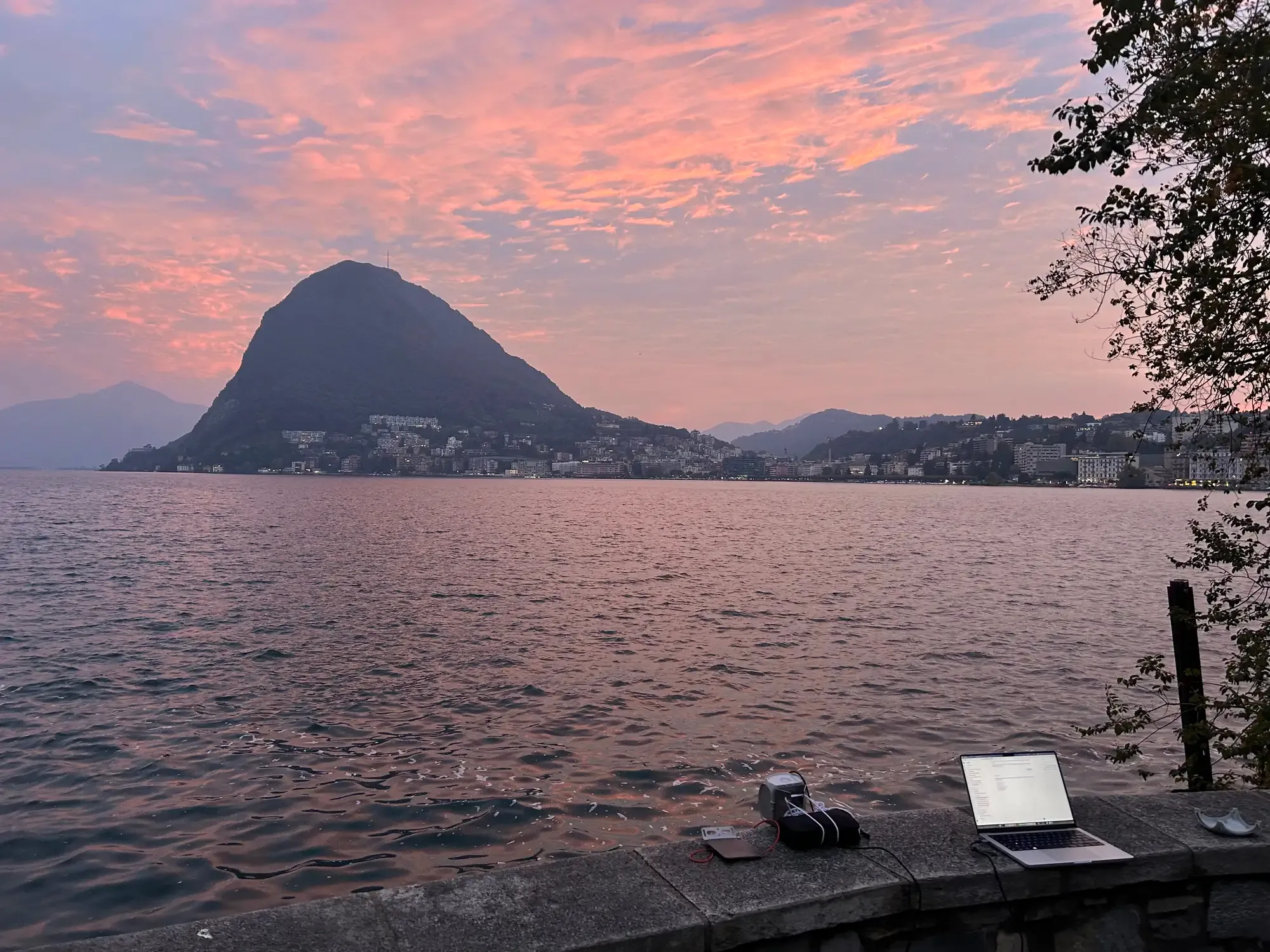
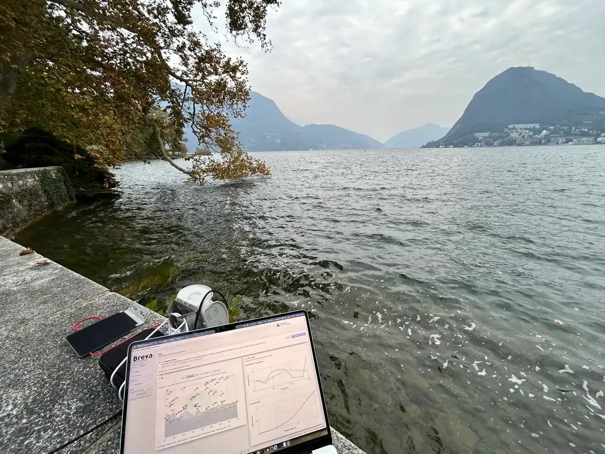
Test session on a lake: the unit on the wall measured 2.276 m to the water and reported it over Iridium in 40 bytes.

0parts in the water

No pressure tube, no float, no radar over the stream. Nothing for floods or debris to destroy.

≈ 1 hto install

Fix it to a wall, a pole or a bridge, aim it at the water on a map, verify it live, leave.

Globalcoverage by satellite

Iridium reports from places with no mobile network and no mains power.

cmlevel precision

Computed on board from every satellite pass, with a quality check on each one.

Who needs it

Start from the question you have to answer.

Dam and reservoir operator

"What is the level today, and is my gauge right?"

A reservoir level every session from a unit on the crest or the shore, independent of the existing gauge, with no part in the water and no cables to the lake.

Then: watch how the dam itself responds to the level with GeoGuard units, which add continuous millimetre displacement monitoring.
Regional flood monitoring

"Which rivers and lakes are rising across the region?"

Many low-cost gauges along a basin, installed in an hour on a bridge or a bank, powered by a small panel and reporting over satellite where there is no mobile coverage. A survey run tells you on day one whether a site works.

Then: GeoGuard units at the critical points, monitored continuously for warnings in real time.

Networks and research

"Can our network also measure water?"

Weather and hydrological station networks add a dedicated water-level gauge next to their stations. A reflexa unit does one job, reflectometry, and reports a few bytes per session; arcs and diagnostics download over USB.

Then: full BREVA processing of the data for long, validated water-level series.

A reflexa unit measures water level only, by reflectometry. It is not a real-time alarm and does not measure displacement: it works in sessions and reports a summary. Continuous monitoring and displacement are done by GeoGuard units.

How it works · GNSS interferometric reflectometry

One antenna hears every satellite twice.

C/N0 vs sin(elevation)dB-Hz
PeriodogramRH —
directreflected

The signal

One antenna, two paths

A GNSS antenna near water hears every satellite twice. The reflected copy travels an extra distance that grows with the antenna height and the satellite elevation.

Δpath = 2 · H · sin(e)

The measurement

From oscillation to height

Seen against sin(elevation), the signal strength oscillates at a constant rate. A Lomb–Scargle periodogram finds it; the wavelength λ of the L1 signal turns it into metres.

H = f · λ / 2   λ = 19.03 cm

The footprint

Tens of metres of water

Low satellites reflect far away, high ones close by. For a 3 m antenna, reflections at 5° come from about 50 m out, so waves average out and nothing touches the water.

d ≈ H / tan(e)

The field console

Install, verify, maintain. One app, on site.

Normal mode guides an installation in five pages. Advanced mode exposes every setting and diagnostic. macOS, Windows and Linux.

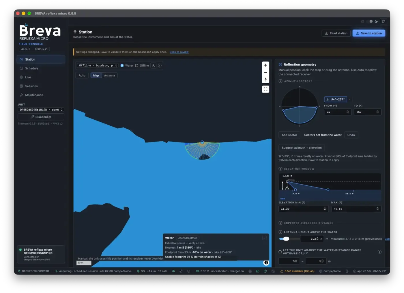
Field console screenshot
Station page, Normal mode, Lake Como: sector set from the water, 12°–33° Fresnel zones mostly on water, terrain shadow, measured antenna height 4.13 m.

Field results

Measured on the lake, received by satellite.

A 32-minute session on Lake Lugano. The unit computed the water distance on board and sent a 40-byte report over Iridium.

The unit on a lake-side wall in Lugano with a laptop running the field console

Iridium report · format C3 · 40 B

2.276m
Antenna to water (RH)
2.276 m
Spread of the session
27 mm
Arcs used / seen
11 / 11
Window
15:41–16:13 UTC
Median peak / noise
3.6
Battery
3.36 V

c3 74 18 5e 18 46 d0 35 d6 03 62 01 1c 8d c0 e8 2e 20 b3 e0 f0 15 40 a9 10 e0 01 fc a4 40 da 07 ea d0 d2 17 c0 d0 9b 10

Technical datasheet

BREVA reflexa

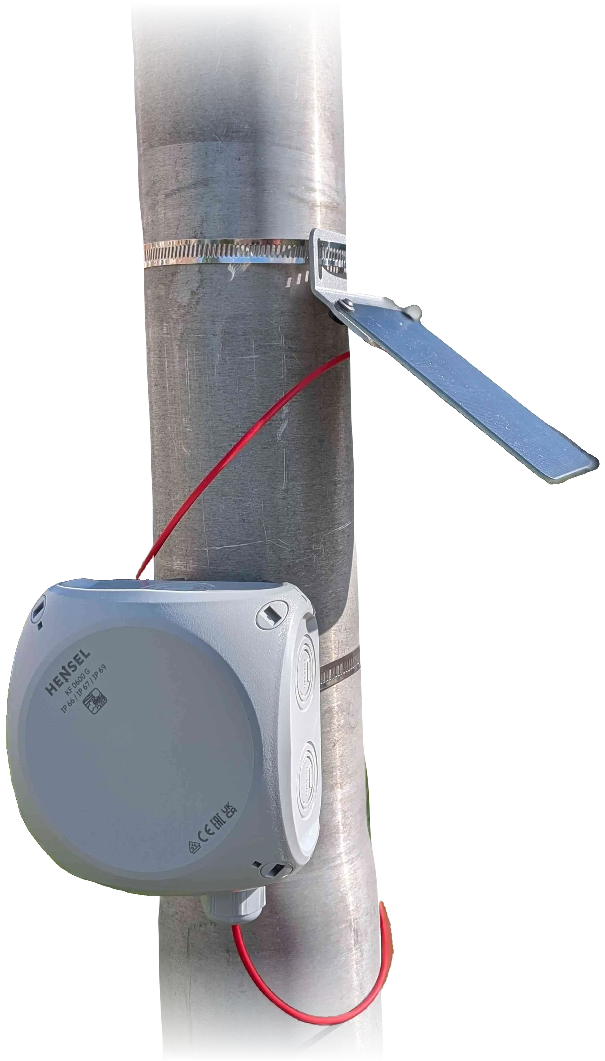
The reflexa unit on a pole: solar panel, enclosure and red solar cable
Photo: TAHMO WLM

Measurement

Principle
GNSS interferometric reflectometry (C/N0)
Quantity
antenna-to-water distance (RH)
Precision
centimetric
Typical antenna height
1–10 m above the water
Elevation window
5°–45°
RH search range
automatic, self-correcting
Processing
on the unit, per arc and per session

GNSS

Receiver
u-blox SAM-M10Q, integrated patch
Signals
L1 / E1 / B1, single frequency
Constellations
GPS · Galileo · BeiDou · GLONASS · QZSS
Rate
1 Hz
Concurrent arcs
up to 32

Telemetry and storage

Modem
RockBLOCK 9704 · Iridium IMT
Report
≈ 22 B default, ≈ 34 B with position
Sending
end of session · every N h · every N results · daily
On-board storage
≈ 7,300 records, kept until downloaded
Local interface
USB-C

Power and environment

Battery
LiFePO4 26650, ≈ 3,000 mAh
Charging
solar or USB, 500 mA, 0–60 °C
Protection
battery guard, dual watchdog
Status
3 LEDs, readable without a computer

Software

Field console
macOS · Windows · Linux
Offline maps
global lakes pack, terrain, OSM water
Updates
guided, with backup and checks
Full specificationsfield-test beta · values from firmware/app 0.5.5 · energy figures to be measured

Downloads

Latest releases

Tester access. During the beta, downloads need the read-only release key you received with the unit, the same key the field console uses for updates.

Reading the release index…

Manual

From the box to the first water level

The full manual lives in the documentation. The same pages open from the "?" button inside the app.

Chapter 1

Install the unit

Before you start: a charged unit, a data-capable USB-C cable, the field console, and a tape measure for the antenna height.

  1. Mount the unit where it sees the open sky and the water between 5° and 45° of elevation.
  2. Fix it firmly: any movement of the antenna reads as a change of water level.
  3. Measure the antenna height above the water and note the time.
  4. Connect the unit; the app finds it and sets its clock if needed.

From one unit to continuous monitoring

The same signals also see structures move.

A reflexa unit does one thing, water level by reflectometry, where a small self-powered gauge is enough: it measures in sessions and reports a few bytes a day. Where water and structures must be watched continuously, GReD runs reflectometry as a service together with GeoGuard GNSS displacement monitoring, on larger units built for harsh environments that support up to two antennas each.

GeoGuard
Reservoir level and crest displacement · dailyday 0
Displacement vs levelr —
water level (GNSS-IR)point Apoint B

Real data from a monitored dam, anonymised: level in metres above the period minimum, horizontal displacement of two GNSS points on the crest along their main direction, daily means.

reflexa unitGeoGuard + GReD reflectometry
Best forRemote lakes, rivers, surveys; places without power or networkDams, reservoirs, bridges, coastal and critical infrastructure
MeasurementSessions; a summary per sessionContinuous, every satellite pass, multi-receiver
HardwareCompact single-antenna unit, solarLarger units for harsh environments, up to 2 antennas per unit
Data linkIridium, a few bytes per dayContinuous upload, full raw data
ProcessingOn the unitBREVA processing chain, validated time series
MeasuresWater level only (reflectometry)Millimetre 3D displacement, water level by reflectometry, other integrated sensors, correlations, alerts, dashboard and API

Start with a reflexa unit, scale to continuous monitoring on the same site and the same signals. More on continuous monitoring at geoguard.eu.

Open the 3D viewinfo@gred.eu
GReDTAHMOUnit hardware designed with TU Delft
BREVA reflexa · software by GReD · unit hardware: TAHMO WLM board, designed with TU Delft (credits to confirm)docs version 0.5.5